Chapter 2
The Sparzak and Rykoski families, discussed in detail in subsequent chapters, settled in the Locust Point and South Baltimore neighborhoods upon their arrival from Poland. This chapter describes the development of these neighborhoods, their connection to German and Polish immigration, and life at the turn of the 19th Century.
Whetstone Point (1661-to-1845)
The Sparzak family lived in Mlawa, Poland before immigrating to the United States. Mlawa is a city in central Poland, in the Mazovian Province, located 70 miles north of Warsaw and 50 miles south of Olsztyn. It was granted town rights in 1429 and in the 16th century became the capital city of the Mlawa District. It prospered because of its location along a favorable trading route leading from Russia to Germany (formerly Prussia). From its earliest days it had a customs house and served as a cattle-trading center.
Present day Locust Point is a narrow peninsula of land extending east from Baltimore harbor between the Northwest and Middle branches of the Patapsco River. Charles Gorsuch obtained a 50 acre land grant there in 1661, but no development took place. Forty years later, in 1702 James Carroll of the famous Carroll family obtained the land and named it Whetstone Point, possibly after a park in London. Four years later, the Maryland House of Delegates designated Whetstone Point as an official port of entry in the upper Bay area, even though only ten ships a year traveled to Baltimore, all docking at Fells Point.
Industrial development began twenty-five years later in 1727 when the British-owned Principio Company bought the right to mine iron ore, which had been discovered there, and constructed an iron foundry. Baltimore itself grew slowly during this period. There were only 100 residents living in the City by 1750. This changed about a decade later when settlers began exporting locally-grown wheat and flour to Britain and the West Indies.
Direct Ancestors
1 Departing Poland (late 1800s)
2 Locust Point, Md. (1600s to 1900s)
3 Sparzak Family (1890s-1900s)
4 Rykoski Family (1910s-1980s)
–Life as a Baltimore Longshoreman
–WW II Memories of Locust Point
5 Stanley & Sophie Waskiewicz Family
— –Lollie, Carolyn & Tony Waskiewicz
6 Charlie & Teenie Rykoski Bernady
8 Anna ‘Annie’ Laura Rykoski Coulborn ALLEN
9 Anthony Jr. & Marjorie Rykoski
The rise of Baltimore from a sleepy town trading in tobacco to a city rivaling Philadelphia, Boston, and New York occurred during the period 1752 to 1773. It began when Dr. John Stevenson, a prominent Baltimore physician and merchant, began shipping flour to Ireland. The success of this seemingly insignificant venture opened the eyes of many Baltimoreans to the City’s most extraordinary advantage– a port nestled alongside a vast wheat growing countryside, significantly closer to this rich farm land than Philadelphia.
The town exploded with energy, and Baltimoreans restructured the City’s economy based on flour. Trails heading west were transformed into roads; flour mills were built along the Jones Falls, Gwynns Falls, and Patapsco River; and merchants built warehouses on thousand-foot long wharves that extended into the harbor. Soon, the roads from Baltimore extended all the way to Frederick County and southern Pennsylvania, and Baltimore ships sailed beyond Ireland to ports in Europe, the Caribbean, and South America.
A fort was constructed at Whetstone Point’s eastern end in 1776 during the Revolutionary War to protect the city. After independence, the new U.S. Congress recognized Baltimore’s military importance and replaced the original fort with a larger one in 1794 to defend Baltimore’s harbor entrance. Fort McHenry was completed in 1805 and held-off the British bombardment in September 1814, saving the city from destruction and inspiring Francis Scott Key to write the Star Spangled Banner.
Whetstone Point was annexed by Baltimore in 1816. Surveyor Thomas Poppleton was commissioned to survey the Point in 1823. His plans showed no houses, but included a design of streets and intersections. He named the streets after War of 1812 heroes and other significant places. Fort Avenue is named for Fort McHenry; Decatur Street is named for Stephen Decatur; Hull Street for Cornelius Hull; and Towson Street for Gen. Nathan Towson. Private Jacob Haubert and Lieutenant Gregorious Andre were killed at the Battle of North Point and privates Thomas Beason and Emery Lowman were killed during the Fort McHenry bombardment. Joseph Nicholson commanded an artillery company at Fort McHenry.
The B&O Railroad and Industrial Development (1846 to 1869)
The peninsula was renamed Locust Point in 1846, because of the many locust trees growing on the peninsula. It became economically important when the Baltimore & Ohio Railroad selected it as an alternative to Fells Point as a major shipping port to solve a logistical problem. Trains were used to transport cargo to and from Fells Point, located east of downtown Baltimore. But Baltimore City officials refused to permit locomotives to travel through the downtown area. Consequently, cargo was either transferred to horse drawn wagons, or train cars were harnessed to horses and pulled along tracks between Fells Point and the Pratt Street yards located west of downtown.
A newly constructed Locust Point cargo terminal became operational in 1851, spurring growth of factories and businesses near the new shipping facilities. These included the Baltimore and Cuba Smelting and Mining Company, which imported and smelted Cuban copper, and Ellicott’s Furnace located at the end of Hull Street. Johns and Brothers operated a large forge on Beason St., west of Decatur. Two brick production facilities and brickyards were operational by 1869: Chase’s located on Decatur Street and Dixon’s located on Fort Avenue near the entrance to Ft. McHenry. At one point, in 1876 there were four brick yards located in Locust Point.
The Immigration Period (1867-1914)
Residential development accelerated after 1867 when the B&O Railroad and the North German Lloyd Steamship Line collaborated to turn Locust Point into a major immigration port. John Garrett, the B&O President determined that Baltimore should have a transatlantic steamship line to carry post-Civil War trade. North German Lloyd Company, a major German shipper based in Bremerhaven agreed to run iron steamers between Baltimore and Bremen. Garrett and the B&O built modern berthing facilities next to the coal piers and a passenger terminal for the arriving immigrants.
North German Lloyd simplified travel across borders, providing point-to-point travel Germany and Poland directly to Locust Point and by train to the American Midwest. Emigrants could buy a package that included a rail ticket to Bremerhaven, passage on a steamship to Baltimore and, depending on their plans, travel on the B&O to the Midwest.
Initially about 25% of arriving immigrants settled in Maryland, many staying in Locust Point and nearby Riverside. By 1890 less than 10% stayed. Immigrants often stayed at a boarding house located next to Pier 9. It was operated by Augusta Jennie Koether from 1869 until 1914. She received 75 cents a day from the steamship companies to house and feed immigrants and at one point fed as many as 40,000 immigrants per year.
Between 1868 and 1914 an estimated 1.2 million immigrants arrived at Locust Point, making Baltimore the third largest port of entry behind New York (Ellis Island) with 17 million and Boston with 1.7 million. This flow was stemmed when Congress severely limited immigration in the 1920s. Although the North German Lloyd line resumed service to Baltimore in 1926, the City never returned to prominence as an important immigration port, and most European immigrants entered the U.S. through New York. On October 30, 1917, a fire destroyed immigrant pier 9 and the immigration station, and Baltimore thus lost these important markers of her immigrant history.
Most Locust Point residents were newly arrived immigrants—Germans and some Irish from the 1850s through the 1880s; Poles in the 1880s and 1890s; Hungarians in the 1890s and 1900s; and in the 1920s, some Italians and Russians. Because of Baltimore’s ground rent system and the many ethnically-sponsored building and loan associations in the city, the majority of the homes in Locust Point were owned by the families who lived in them. Various nationalities tended to cluster on certain streets in certain periods—for example, there were always large numbers of Polish residents on Andre and Reynolds Streets—but Germans could be found everywhere.
The Sparzaks and Rykoskis were part of this large immigration movement. Many family members traveled from Poland to Locust Point, obtained employment as stevedores and other trades, and settled on and near Reynolds Street.


Residential Development (1848-1910)
Locust Point had little residential development when the B&O Railroad decided to use it as a shipping port and progress was slow. An 1849 newspaper article published this description of Locust Point:
More than twenty houses, including a Methodist chapel have been erected, and the aspect of the place is that of bustling activity. A year or two since, nothing but barren waste covered with weeds and prickly brush could be observed. At the present time, steam cars whiz over inclined planes, with cars filled with merchandize, the wharves are enlivened with the presence of a fleet of vessels, with their sails flapping in the breeze, whilst the enlivening sound of the anvil and the tinkling of the trowel indicate an increasing prosperity at Whetstone Point.
Most workers commuted to Locust Point from other parts of Baltimore. Even 20 years later, in 1869, there was a limited supply of residential housing. Baltimore and Cuba Company had built some two-story rows, a three-story row on the west side of Hull St. and three similar houses further south on the east side of Hull.
At the end of the 1860s, however, the newly formed Locust Point Company acquired land rights and built a row of three-story houses on the west side of Hull St., north of Beason. Further north on Hull there was a large three-story porch-front building that served as a boarding house for railroad and other local workers since there was so little housing in the area.
Most Locust Point residences were built between about 1884 and 1901 and tended to be more modest than row houses built in other Baltimore neighborhoods.
Larger three-story row houses were 18’ wide (three-bay) and had an entry that opened into a hallway that led to the stairs and rear rooms, maintaining the front parlor as a formal room. In addition to gas lighting (there was no electricity in the mid-1800s) they also typically included gas-fueled hot-air furnaces, running water and bathrooms. The three-story 18’ wide homes were built for more affluent factory managers and owners. In addition to those built along Hull Street these houses were more popular in the Riverside area of South Baltimore.
While some two-story houses were 18’-wide with an entrance hallway, more affordable versions were 12’ wide (two-bay) and the front entrance opened directly into the parlor. In Locust Point concerned citizens pressured builders to construct smaller houses that were more affordable for the working classes. To ensure affordability two-story, 12’-wide row houses often had only gas lighting, coal furnaces, and no indoor plumbing.
Consequently, the typical Locust Point block configuration consisted of two-story, two-bay-wide houses. Corner houses were typically three stories in height so the owner could live on the upper two floors and operate a store, restaurant, or saloon on the first floor. There were groups of 18’-wide houses built on Fort Avenue’s north side, east of Decatur Street. (1400-to-1420 and 1428-to-1442 Fort Avenue). There was also a long row of two-story, three-bay-wide houses on the east side of Hull St., south of Beason, at 1301-to-1339 Hull, built in 1886 by George W. Delia.
Churches and Public Buildings
The Lawrence O’Toole Chapel was the first Roman Catholic Church, completed in 1859 and located on the north side of Fort Avenue, east of Hull. As Locust Point grew, and Catholics became its largest denomination, they built a much larger Gothic Revival-style stone church, Our Lady of Good Counsel, laying the cornerstone in 1889. The O’Toole Chapel became a school, eventually run by the School Sisters of Notre Dame. In the 1930s, the Sisters had the chapel demolished and constructed a school which was operated until the 1970s. Our Lady of Good Counsel’s bell tower has four bells, one to honor the Irish, one to honor the Germans, one to honor the Poles, and one in memory of those who are here and yet to come.
The Locust Point Union Mission Chapel opened in 1871 on the west side of Hull St., just north of Fort, but the building no longer survives. A block further north on Hull, north of Clement, the Locust Point Tabernacle of Baltimore City opened in 1887, which became the 4th Congregational Church a decade later, but that too has been demolished. In 1877, the Episcopalian Diocese of Baltimore established a mission to help immigrants adjust to life in an industrial city.
The last church built on Locust Point had a decidedly ethnic character. A German United Evangelical Christ Church was constructed during 1887-88 at the northwest corner of Beason and Decatur Streets (1308 Beason); the congregation followed the German Reformed tradition. Prior to World War I, all services were in German, and then in German and English thereafter. In 1972, the church affiliated with the United Church of Christ. The name of the church, in German, can still be seen carved above the entrance doors. In 1904, the Church built and then operated an Immigrant House, just west of the church on Beason, to provide a place for German immigrants to stay before they traveled elsewhere or while they were looking for work and/or a home in Baltimore. The building also housed German sailors while their ships were in port.
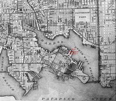
One other important quasi-public building still stands in the Historic District at 1300 Hull St. First known as Eintracht Hall, for the German Eintracht (Harmony) singing society, the long brick building occupies almost the whole length of Beason St., west from Hull to Haubert. The Hall opened in 1887 and by the turn of the century was known as Otterbein Hall, in honor of George T. Otterbein, president of the Eintracht Stock Co., which acquired the site and built the hall. The Hall not only served as a social gathering place, it also hosted the Turn-Verein gymnastics events so important to both German and Bohemian immigrant communities. The following map shows the area layout in 1906.
Employment
The B&O railroad was the largest Locust Point employer because of its rail yards, round-house, grain elevators, coal piers, and repair facilities. The fertilizer industry was also a large employer. Locust Point also hosted two ship yards, including the Woodall Shipbuilding Company and the Skinner Ship Building Company.
Six stevedoring companies operated on Locust Point in 1916, but stevedores averaged only 3 days of employment per week. Stevedores generally earned $6 a week while most other labor occupations paid $12 a week.
Only 18% of the adult women and 5% of women with children were employed in 1916. However, since stevedore pay was erratic many stevedores’ wives and children worked in nearby canneries and packing houses, shucking and canning oysters in the winter months and packing fruits and vegetables in the summer. There were four cannery packing houses located on or near Locust Point in 1916.
Social Life and Home Ownership
By 1916, Locust Point was home to 31 saloons, patronized mostly by men. Locust Point had two movie theatres. There were 6 public dance halls that were connected to saloons. In addition, the Paret Memorial Parish House sponsored dances, as did the Catholic Church. The Settlement House on Fort Avenue, a nonsectarian outreach center helped immigrants to assimilate and also held dances and dancing classes. Young people traveled by ferry to the Recreation Pier on Fells Point for dancing. At that time, Locust Point residents also enjoyed nearby Fort McHenry Park, which had a bathing beach, carousel, and weekly band concerts and Latrobe Park with its athletic fields and playground.
One important characteristic of housing on Locust Point is that over 70% of homes were owned by their residents in 1916. With the help of many ethnically-based as well as local building and loan associations the newly arrived immigrants finding work in Locust Point were able to become homeowners in a relatively short period of time.
Reynolds Street
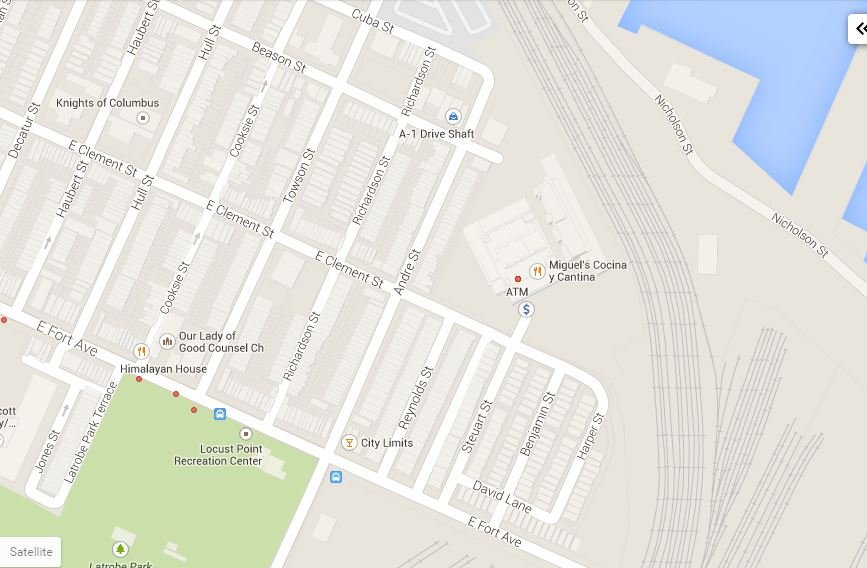
The 1400 block of Reynolds Street, where the Sparzaks and Rykoskis lived in the early 1900s is located on the north side of Fort Avenue, between Andre and Reynolds Streets. The block was originally named Garrett Street but was renamed Reynolds Street in the early 1900s. The 1300 block of Reynolds street was demolished in 1924 to make way for construction of the B&O Grain Elevators.
Builders Jacob and Adolph Rosenthal built the long rows on the southern portion of either side in 1884. Another prolific local builder, Jacob Saum and his brick-making partner Y.O. Wilson built the rows on either side of the northern section of Reynolds Street a year later, in 1885. The 11’6″- wide houses at 1400-to-1416 and 1401-to-1417 Reynolds closely resemble those built by the Rosenthals. Saum and Wilson also built the long row of 12′-wide houses on the east side of Andre St., at 1401-to-1463 Andre, and the short row on the north side of Fort Avenue, at 1700-to-1708 Fort in 1886. Each long row of houses has a wider storefront unit at the corner (ranging in width between 13′ and 16’), usually outfitted with shop-front windows set on either side of a diagonally-placed center door.
Locust Point Map – 1920

Locust Point Map – 2015
Locust Point Fire House
